Large areas of north India have seen constant heavy rain as a result of a unique event caused by the confluence of two meteorological elements, with visuals evoking the 2013 “Himalayan Tsunami” that hit Uttarakhand. The condition that occurred during the 2013 “Himalayan Tsunami,” which caused flash floods in Kedarnath and resulted in hundreds of fatalities and significant property loss in the area, is strikingly similar to that seen in the satellite photographs taken by INSAT.
The latest phenomenon caused Delhi to record 153 mm of rain in 24 hours on Sunday, the greatest for a single day in July since 1982, according to the India Meteorological Department. In the meantime, Himachal Pradesh and Uttarakhand are already under a heavy rain alert with flash flood warnings.
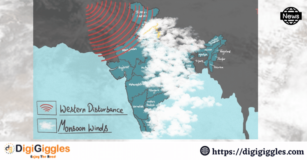
According to the Indian Meteorological Department (IMD), the monsoonal winds’ interaction with the western disturbance that has caused a trough above Himachal Pradesh is what is causing the heavy rain in some areas of Himachal Pradesh and Uttarakhand. According to the most recent IMD assessment, a low-pressure area is present over northeast Rajasthan and the nearby areas.
According to an IMD bulletin, the western disturbance and monsoonal winds are predicted to interact during the next 24 to 36 hours, causing heavy rainfall across most of northwest India. The Indian monsoon includes such circumstances, but they are still uncommon. The intensity and spread of the rains have increased due to the interaction of the monsoonal winds with the western disturbance, according to IMD Shimla Director Surender Paul.
An extratropical cyclone or low-pressure system known as a “Western Disturbance” develops in the Mediterranean Sea and moves eastward across Iran and the Middle East, bringing weather changes to the Indian subcontinent. The weather in northern India is significantly impacted by Western disturbances. These disturbances cause cloud cover, precipitation, and occasionally snowfall in the higher elevations of the Himalayan region as they move toward the northwest of the country.
The Indian monsoon is caused by seasonal wind patterns that prevail in the Indian subcontinent, which are referred to as monsoonal winds. These two winds, the Southwest and Northeast Monsoons bring India’s necessary rainfall in the summer and winter.
In Uttarakhand in 2013, the “Himalayan Tsunami” was brought on by a number of events, including protracted monsoon rainfall. Although the natural barrier holding back a glacier lake burst, this wasn’t the only reason why it happened; there was also a deeper underlying reason. Scientists realized that the destruction was caused by a more complex chain of circumstances. The devastating event was brought on by a confluence of intense precipitation, a warmer and less stable snowpack, and a worrying glacial instability brought on by climate change.
The effects of this instability go far beyond the area immediately surrounding the high peaks, posing a serious threat to the area for many years. The shifting monsoon patterns were also mentioned as a probable cause of the violent incident.
The IMD has warned of flash floods in numerous northern Indian states brought on by heavy rains, while it has not yet stated that the rains could cause as much destruction as what occurred in Uttarakhand in 2013. The Indian Meteorological Department (IMD) has issued warnings for Himachal Pradesh, Uttarakhand, extreme north Punjab & Haryana, Uttar Pradesh, Rajasthan, Sub-Himalayan West Bengal & Sikkim, Arunachal Pradesh, Assam & Meghalaya, and Bihar, which may see very heavy rainfall on Monday and Tuesday.